 By Sanjeev Sinha
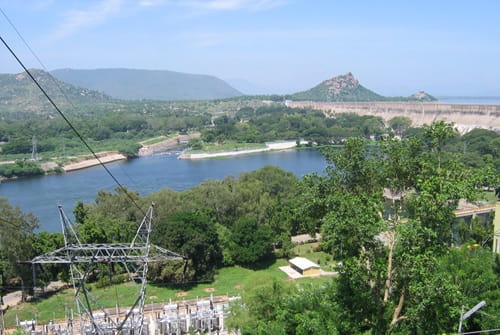
 Mettur Dam, Tamil NaduIf you’ve ever eaten Tamil Nadu rice, sipped sugarcane juice from the state, or wondered why the Cauvery water-sharing dispute keeps making headlines, Mettur Dam is where a lot of that story actually plays out. This isn’t just Tamil Nadu’s largest dam — it’s the single structure that decides how much water reaches over 2.4 million acres of farmland across the Cauvery Delta. For anyone travelling through Salem district, or simply trying to understand why this dam gets mentioned so often in the news, here’s a clear, practical guide.
Quick Overview
| Detail | Information |
| River | Cauvery (Kaveri) River |
| Location | Mettur, Salem district, Tamil Nadu |
| Distance from Salem | Around 40–55 km |
| Nearest Railway Station | Mettur Dam Railway Station, or Salem Junction (about 44–55 km) |
| Nearest Airport | Salem Airport, roughly 40 km away |
| Construction Started | 1925 (proposals date back to 1834) |
| Completed | 1934 |
| Chief Engineer | Vincent Hart, Irish engineer, Madras Presidency |
| Construction Workforce | Around 17,000 workers over 9 years |
| Reservoir Name | Stanley Reservoir |
| Dam Height | Around 50–65 metres (roughly 120 feet water capacity) |
| Dam Length | About 1,700 metres |
| Irrigation Coverage | Around 2.4 million acres across Tamil Nadu |
| Visiting Hours | Generally 8:00 AM to 6:00 PM (sunrise to sunset per some sources) |
| Entry Fee | Free (small charges for the adjoining park) |
| Best Time to Visit | October to February |
Where Mettur Dam Is Located
Mettur Dam sits in Salem district, right at the point where the Cauvery River emerges from the foothills of the Western Ghats onto the plains. It’s roughly 40 to 55 kilometres from Salem city, depending on your route, making it an easy half-day trip if you’re already based there.
Getting to Mettur is straightforward. Salem Junction serves as the major railway connection, though there’s also a dedicated Mettur Dam Railway Station closer to the site itself. Salem Airport is your nearest air link, and regular buses and taxis run from Salem, Erode, and even as far as Coimbatore, making the town reasonably well connected despite its relatively quiet, industrial character.
The River Behind Tamil Nadu’s Agricultural Backbone
Mettur Dam is built across the Cauvery River, the same river responsible for feeding the fertile Cauvery Delta further downstream, including areas around Thanjavur and Tiruchirappalli. What makes Mettur’s role so significant is its position — sitting right where the river transitions from hilly terrain into the plains gives this dam enormous control over how much water eventually reaches the delta’s farmlands.
The reservoir created by the dam, known as Stanley Reservoir, effectively acts as the master regulator for Tamil Nadu’s Cauvery-dependent agriculture, deciding water releases that directly affect crop cycles for rice, sugarcane, and cotton across the state.
A History Rooted in Nearly a Century of Planning
The idea of building a dam here to regulate the Cauvery’s flow and prevent flooding was actually first proposed way back in 1834, though it took nearly a century for the project to move from concept to construction. Credit for finally initiating the project goes to Vincent Hart, an Irish engineer serving as chief engineer of the Madras Presidency, who championed the plan starting around 1924.
Construction began in 1925 and wrapped up in 1934, an enormous undertaking that required roughly 17,000 workers over nine years. As part of the project, the British government provided compensation to residents of Nayambadi, a town that once stood where the dam and reservoir now sit, helping relocate them before the area was submerged. Many of these displaced families settled in what is now Mettur town and neighbouring areas like Martalli.
Interestingly, when the reservoir’s water level drops significantly, remnants of old Hindu shrines and churches from the submerged area occasionally become visible again, offering a rare, temporary glimpse into what existed here before the dam was built.
What Mettur Dam Does Today
Beyond irrigation, Mettur Dam plays a major role in Tamil Nadu’s power supply through its hydroelectric station, and the nearby Mettur Thermal Power Station adds further generation capacity, making this entire area one of the state’s more important energy hubs. The dam’s 16 sluice gates are genuinely impressive to see, particularly when they’re opened to release excess water during high-flow periods.
The dam’s operation isn’t without controversy, though. Since the Cauvery’s flow directly affects both Tamil Nadu and neighbouring Karnataka, water release decisions at Mettur have historically been tied to broader interstate water-sharing tensions, making this dam as much a political talking point as an engineering one.
What There Is to See and Do
The Mettur Dam Park, maintained by the Tamil Nadu Public Works Department, sits right opposite the dam and offers a genuinely pleasant green space with walking paths, flower beds, and a dedicated children’s play area. It’s become a popular local spot for families to relax and enjoy views of both the dam and the surrounding hills.
A tower resembling a small lighthouse near the dam gives visitors an elevated vantage point to appreciate the scale of the structure and the water outlet paths below. Boating on the Cauvery near the dam is available at certain times, though this tends to be seasonal, so it’s worth checking availability before planning your visit around it. Fresh fish fry from nearby stalls is a local specialty many visitors specifically recommend trying.
One particularly interesting time to visit is during the Tamil month of Aadi, typically falling in July-August, when the Cauvery swells with monsoon water and nearby communities gather for traditional celebrations around the river — a genuinely unique cultural experience layered on top of the dam’s engineering appeal.
Timings and Entry Details
Most sources place general visiting hours somewhere between 8:00 AM and 6:00 PM, with a few describing access as running from sunrise to sunset instead. Entry to the dam itself is free, though the adjoining park and nearby attractions like Ellis Park typically charge a small admission fee, generally in the range of ₹10 to ₹50.
Given that this is a functioning, strategically important dam, visitors shouldn’t expect close access to every part of the structure — most sightseeing happens from designated viewing areas and the park rather than the dam itself.
Best Time to Visit
October through February remains the ideal window, bringing cooler, more comfortable weather for sightseeing and walking around the dam and park area. Visiting right after monsoon, particularly in October or November, gives you the best chance of seeing the reservoir at a fuller, more impressive level, with water flow at its most dramatic.
Frequently Asked Questions
Q1. Why does Mettur Dam get mentioned so often in news about water disputes?
Since it sits at the point where the Cauvery River enters Tamil Nadu’s plains from the hills, decisions about water release at Mettur directly affect both Tamil Nadu’s agriculture and the broader Cauvery water-sharing arrangement with Karnataka, making it a frequent talking point in interstate water discussions.
Q2. Can visitors get close to the dam structure itself?
Not entirely. Most sightseeing happens from designated viewpoints and the adjoining Mettur Dam Park rather than the dam structure directly, since it remains an active, strategically important piece of infrastructure.
Q3. Is boating available at Mettur Dam?
Boating is sometimes available on the Cauvery near the dam, but it tends to be a seasonal activity depending on water levels, so it’s worth checking current availability before planning your visit around it.
Q4. What’s the best time to see old submerged structures near the dam?
During periods of significantly low water levels, remnants of the old Nayambadi settlement, including shrines and churches, occasionally become visible, though this isn’t a guaranteed or predictable occurrence and depends entirely on current reservoir levels.