 By Sanjeev Sinha
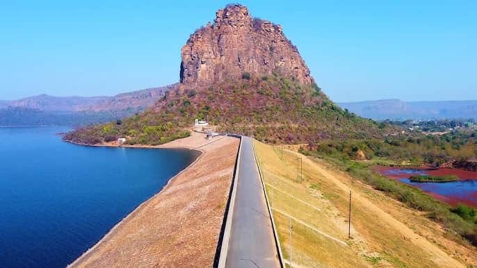
 Ask anyone from Bihar’s Rohtas or Kaimur belt about a hidden gem worth a weekend drive, and Karamchat Dam almost always comes up. People call it the “Switzerland of Bihar,” and once you see hills wrapping around calm blue water with barely another soul around, you understand why. This isn’t just a scenic reservoir, though — it’s the result of a project born from famine, delayed by decades of legal and political hurdles, and finally completed to bring water security to farmers who’d waited generations for it. Here’s everything worth knowing before you plan your trip.
Quick Overview
| Detail | Information |
| Also Known As | Durgavati Dam |
| River | Durgavati River |
| Location | Karamchat village, near Chenari, Rohtas district, Bihar |
| Distance from Sasaram | Around 35–44 km |
| Nearest Railway Station | Khurmabad Road, roughly 14 km away |
| Approach Road | Well connected via NH2 |
| Original Concept | 1966, following a severe famine |
| Foundation Stone Laid | 10 June 1976, by Union Agriculture Minister Babu Jagjivan Ram |
| Work Resumed After Delay | 2012 |
| Inaugurated | 15 October 2014, by then Chief Minister Jitan Ram Manjhi |
| Dam Height | Around 46.3 metres |
| Dam Length | About 1,615 metres |
| Total Storage Capacity | 287.7 million cubic metres |
| Catchment Area | Around 627 sq. km of Kaimur hills |
| Irrigation Coverage | Around 17,000+ hectares across Rohtas and Kaimur districts |
| Visiting Hours | Generally 6:00 AM to 6:00 PM |
| Boating Cost | Around ₹50 per person, or ₹550 to reserve an 11-seater boat |
Where Karamchat Dam Is Located
Karamchat Dam sits near Chenari, roughly 35 to 44 kilometres from Sasaram in Rohtas district, right on the border shared with Kaimur district. The dam is easily accessible via NH2, making it a convenient road trip destination if you’re travelling through this part of Bihar rather than requiring a dedicated detour off the beaten path.
Khurmabad Road serves as the nearest railway station, about 14 kilometres away, though most visitors reach the dam by road, either self-driving or hiring a vehicle from Sasaram. The road leading up to the site passes through genuinely scenic terrain, with visitors often mentioning small waterfalls scattered along the route, particularly during and after monsoon.
The River Behind This Reservoir
The dam is built across the Durgavati River, which is exactly why it’s also widely known as Durgavati Dam in official records and local conversation alike. The river draws its water from an extensive catchment area of roughly 627 square kilometres across the Kaimur hills, an area known for receiving substantial rainfall that historically went largely unharnessed before this project came along.
That catchment feeds into a reservoir substantial enough to submerge around 2,337 hectares at full capacity, creating the wide, hill-flanked water body that gives Karamchat its distinctive “hidden valley” character.
A History Rooted in Famine and Decades of Delay
The story behind Karamchat Dam begins with tragedy. A severe famine struck the region in 1966, exposing just how vulnerable the plains of Rohtas were without reliable irrigation. This crisis led to the conception of the Durgavati Reservoir Project, envisioned specifically to bring water security to farmland that had gone unirrigated for far too long.
Progress, however, was anything but quick. The then Agriculture Minister A.R. Kidwai and Irrigation Minister K.L. Rao personally inspected the proposed site and gave their approval, and the foundation stone was eventually laid on 10 June 1976 by Union Agriculture Minister Babu Jagjivan Ram. Officials at the time expected canal water to start flowing by 1980.
That timeline didn’t hold. The project faced repeated setbacks, obstacles, and delays for decades, even after a high-level committee was formed in 1977 specifically to clear the roadblocks. It wasn’t until December 2011 that the Supreme Court and relevant ministries finally granted permission for work to resume, with construction restarting in early 2012. By 2014, roughly ₹1,064 crore had been spent on the project, a dramatic increase from earlier estimates, and 184 people affected by the scheme were provided employment as part of the resolution.
The dam was finally inaugurated on 15 October 2014 by then Chief Minister Jitan Ram Manjhi, bringing to completion a project that had spanned nearly five decades from its original conception to its actual opening.
What Karamchat Dam Does Today
With a gross command area of over 40,000 hectares, the dam now irrigates farmland across Chenari, Sivasagar, and Sasaram blocks in Rohtas district, along with Rampur, Bhabua, Bhagwanpur, Kudra, Mohania, and Durgavati blocks in Kaimur district. Canal systems extend on both the east and west sides of the dam, with the right main canal stretching over 34 kilometres to distribute water across this wide agricultural belt.
Beyond irrigation, local reports and Bihar Tourism have also highlighted the dam’s potential for energy production, alongside its growing role as a genuine tourism draw for the state.
What There Is to See and Do
The scenery here is genuinely the main attraction. Hills wrap around the reservoir on multiple sides, covered in greenery that intensifies considerably after monsoon, and sunrise or sunset views over the water are consistently described by visitors as some of the most peaceful they’ve experienced in Bihar.
Boating remains the most popular activity, with clean boats and life jackets reportedly well maintained. A basic per-person ride costs around ₹50, while reserving an entire 11-seater boat runs about ₹550, with the option to extend your ride by another fifteen minutes for an additional charge. Fishing and short hiking trails around the area add further options for visitors wanting more than just a scenic photo stop, and a hidden waterfall along the route toward nearby Gupta Dham has become something of an unplanned bonus for travellers exploring the wider area.
Timings and Practical Details
Most sources place general visiting hours between 6:00 AM and 6:00 PM daily. Amenities remain fairly basic, with a small canteen available for snacks, though it’s sensible not to expect extensive dining options on-site. Several visitor reviews have specifically requested improvements to facilities and a wider range of boats, so it’s worth setting expectations accordingly rather than anticipating a heavily developed tourist complex.
Weekday visits are generally recommended over weekends and holidays if you’re hoping to enjoy the site’s naturally quiet, peaceful atmosphere without larger crowds.
Best Time to Plan Your Visit
Winter and post-monsoon months offer the most pleasant conditions for a visit, with cooler temperatures making boating and walking around the reservoir genuinely enjoyable. Summer is best avoided given the high humidity commonly reported in the region during that period, which can make an otherwise relaxing outing considerably less comfortable.
Frequently Asked Questions
Q1. Why is Karamchat Dam also called Durgavati Dam?
It’s built across the Durgavati River, and the entire irrigation initiative was originally named the Durgavati Reservoir Project, which is why both names are used interchangeably in official records and local conversation.
Q2. Is boating safe at Karamchat Dam?
Generally yes, with visitors reporting clean boats and properly maintained life jackets. That said, some reviews caution about high water flow at certain times, so it’s advisable to follow safety instructions closely, especially if you’re not a confident swimmer.
Q3. Why did it take so long to complete this dam?
The project faced decades of delays due to political, administrative, and legal obstacles after its 1976 foundation stone was laid, with construction only resuming in 2012 following Supreme Court clearance in December 2011, before finally being inaugurated in 2014.
Q4. What’s the best time of day to visit for the nicest views?
Early morning, around sunrise, is widely recommended, both for cooler weather and for catching the reflection of the sky on the calm reservoir water, which visitors consistently describe as one of the most photogenic moments of the visit.