 By Sanjeev Sinha
 If you’ve ever wondered how Surat, one of India’s fastest-growing textile and diamond hubs, manages to keep its water supply steady while also staying largely flood-protected, Ukai Dam deserves a good share of the credit. This is Gujarat’s second-largest reservoir after Sardar Sarovar, and it quietly holds nearly half of all the state’s dam storage capacity combined. If you’re planning a trip out of Surat or simply curious about the dam behind the Tapi’s regulated flow, here’s everything worth knowing.
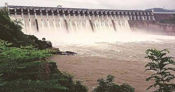
Ukai Dam Quick Overview
| Detail | Information |
| Also Known As | Vallabh Sagar |
| River | Tapi (Tapti) River |
| Location | Ukai, Surat district (also referred to as Tapi district), Gujarat |
| Distance from Surat | Around 93–94 km |
| Construction Started | 1964 |
| Completed | 1972 |
| Dam Type | Earth-cum-masonry dam |
| Status | Second-largest reservoir in Gujarat, after Sardar Sarovar |
| Embankment Length | About 4,927 metres |
| Earth Dam Height | Around 80.77–105.156 metres (sources vary) |
| Masonry Dam Height | About 68.68 metres |
| Catchment Area | Around 62,225 sq. km |
| Water Spread | Approximately 52,000 hectares |
| Storage Share | Around 46% of Gujarat’s total dam storage capacity |
| Power Generation | 300 MW (four 75 MW turbine units) |
| Visiting Hours | Generally 9:00 AM to 5:00 PM |
| Entry Fee | Free |
| Best Time to Visit | October to March |
Where Ukai Dam Is Located
Ukai Dam sits roughly 93 to 94 kilometres from Surat, in what’s officially part of the Tapi district today, though many older references still list it under Surat district given how the administrative boundaries have shifted over the years. It’s a manageable day trip from Surat, making it a popular excursion for both residents and visitors passing through South Gujarat.
The drive out to Ukai typically takes you through scenic countryside, and the site often gets combined with nearby attractions like the village of Songhar and Giri waterfalls, giving visitors more to explore beyond the dam itself.
The River Behind Gujarat’s Second-Largest Reservoir
The dam is built across the Tapi River, one of only three major peninsular Indian rivers, alongside the Narmada and Mahi, that flow east to west rather than the more typical west-to-east pattern seen across most of the subcontinent. The Tapi originates in the Gawilgarh Hills of the central Deccan plateau in Madhya Pradesh, flowing westward through Maharashtra’s Jalgaon plateau before crossing into Gujarat and eventually reaching the Gulf of Khambhat.
Stretching roughly 700 kilometres in total, the Tapi’s catchment area covers about 65,145 square kilometres, with nearly 80 percent of that lying within Maharashtra. Major tributaries feeding the river include the Purna, Girna, Panzara, Waghur, Bori, and Aner rivers, all contributing to the substantial water volume that Ukai Dam ultimately regulates.
A History Rooted in Multipurpose Water Management
Construction on Ukai Dam began in 1964 and was completed in 1972, making it one of Gujarat’s most significant infrastructure achievements from that era. Also known as Vallabh Sagar, the dam was designed with three core purposes in mind — irrigation, hydroelectric power generation, and flood control, addressing needs that were genuinely pressing for a region historically vulnerable to the Tapi’s seasonal flooding.
What makes Ukai’s scale genuinely remarkable is a single statistic worth sitting with: its storage capacity alone accounts for approximately 46 percent of the combined capacity of every other dam in Gujarat put together. This makes Ukai, alongside the Narmada project, one of the two most consequential multipurpose water projects the state has ever undertaken.
A Submerged Fort That Occasionally Resurfaces
Here’s a genuinely unique detail that sets Ukai apart from most Indian dams. When the Vajpur Fort, originally built by the Gaekwad dynasty of Baroda, found itself in the path of the rising reservoir, it was submerged entirely beneath Ukai’s waters. During periods of unusually low water levels, though, this historic structure occasionally re-emerges, offering a rare glimpse of pre-dam history for anyone visiting at just the right time. It’s the kind of detail that turns a routine dam visit into something genuinely memorable if the timing happens to align.
What Ukai Dam Powers and Irrigates
The Ukai Hydro Power Station houses four turbine units, each rated at 75 MW, for a combined installed capacity of 300 MW, all manufactured by BHEL. This power generation capacity makes the dam a meaningful contributor to Gujarat’s electricity grid, alongside its primary irrigation role.
On the agricultural side, the dam’s left bank canal supplies water to roughly 1,522 square kilometres of farmland, while the right bank canal serves an even larger area of about 2,275 square kilometres. Together, these canal systems have transformed water availability across a substantial stretch of South Gujarat, supporting crops that would otherwise depend far more heavily on unpredictable monsoon rainfall.
What There Is to See and Do at Ukai Dam
Beyond its engineering significance, Ukai offers genuinely scenic surroundings, with the vast reservoir and its backdrop making for excellent photography, particularly around sunset. Watching the dam release water at full force, when conditions call for it, is consistently described as one of the more spectacular sights here.
Birdwatching is a genuine highlight, with the area around the reservoir attracting a good variety of local and migratory species. Early mornings and late afternoons tend to offer the best opportunities for spotting them. Fishing is also popular in the reservoir’s calm waters, though visitors need a proper fishing permit before casting a line.
Nearby, Songhar village and Giri waterfalls add extra depth to a day trip, while Saputara hill station, roughly 75 kilometres away, and Gopi Talav, a historical lake about 50 kilometres from the dam, both offer worthwhile extensions if you’re planning a longer excursion through this part of Gujarat.
Timings and Entry Details
Ukai Dam is generally open from 9:00 AM to 5:00 PM, with free entry for visitors. Given the site’s fairly open, exposed setting, it’s worth carrying sun protection like hats, sunglasses, and sunscreen, along with comfortable walking shoes, since much of the visit involves being outdoors near the water’s edge.
Best Time to Plan Your Visit
October through March offers the most comfortable weather for visiting, with cooler temperatures making outdoor exploration, birdwatching, and photography genuinely enjoyable. Monsoon season is generally best avoided given the potential for heavy rainfall and flooding risk in the surrounding area, even though this is technically when the reservoir and its release mechanisms look most dramatic.
Frequently Asked Questions
Q: Can I actually see the submerged Vajpur Fort during my visit?
A: Only occasionally, and it depends entirely on current water levels in the reservoir. The fort becomes visible during periods of unusually low water, so it’s not something you can reliably plan a trip around, but it’s worth asking locally about current conditions if this interests you.
Q: Do I need a permit to fish at Ukai Dam’s reservoir?
A: Yes, fishing requires a proper permit, so it’s advisable to check with local authorities or your accommodation in advance if this is an activity you’d like to include in your visit.
Q: Is Ukai Dam worth combining with other nearby attractions in one trip?
A: Yes, genuinely so. Songhar village, Giri waterfalls, Saputara hill station, and Gopi Talav are all within reasonable driving distance, making it easy to build a fuller day or weekend itinerary around a Ukai Dam visit.
Q: Why does Ukai Dam matter so much to Gujarat’s overall water management?
A: Its storage capacity alone accounts for roughly 46 percent of all dam storage across Gujarat combined, making it one of the state’s two most significant multipurpose water projects, alongside the Narmada project, for irrigation, flood control, and power generation.