 By Sanjeev Sinha
 If you’ve ever driven the Jammu-Srinagar highway and caught a glimpse of a massive concrete structure spanning the Chenab River, you’ve probably seen Baglihar Dam without realising its full significance. This isn’t just a scenic stopover on your way to Kashmir — it’s a 900 MW hydroelectric project that went through years of international arbitration with Pakistan, and it remains one of the most strategically important pieces of infrastructure built on the Chenab in recent decades. Here’s everything worth knowing.
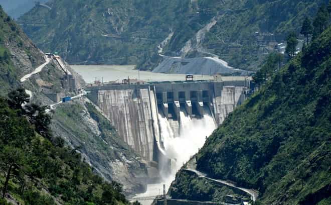
| Detail | Information |
| Also Known As | Baglihar Hydroelectric Power Project |
| River | Chenab River |
| Location | Chanderkote, Ramban district, Jammu and Kashmir |
| Distance from Ramban Town | Around 50 km |
| Approach | Jammu-Srinagar National Highway (NH 1A/NH 44) |
| Project Conceived | 1992 |
| Approved | 1996 |
| Construction Started | 1999 |
| Stage I Completed | 2008-09, dedicated by PM Manmohan Singh |
| Stage II Completed | 2015-16, dedicated by PM Narendra Modi |
| Dam Type | Concrete gravity dam |
| Dam Height | 144.5 metres |
| Dam Length | 363 metres |
| Reservoir Capacity | 475 million cubic metres |
| Power Generation | 900 MW total (two stages of 450 MW each) |
| Executed By | Jammu and Kashmir Power Development Corporation / NHPC |
| Project Cost | Around US$1 billion |
| Best Time to Visit | Year-round, en route Jammu-Srinagar travel |
Where Baglihar Dam Is Located
Baglihar Dam sits at Chanderkote, roughly 50 kilometres from Ramban town, the district headquarters, right along the historic Jammu-Srinagar National Highway. This positioning makes it genuinely easy to encounter, since most travellers making the journey between Jammu and Srinagar pass directly by or near the dam site without needing a dedicated detour.
The dam falls almost midway between Jammu and Srinagar, situated between Ramban and Patnitop, making it a natural stopping point for anyone breaking up this long mountain drive. The reservoir itself extends upstream for a considerable distance, reportedly reaching back nearly 50 kilometres toward Pul Doda.
The River Behind This Strategic Hydroelectric Project
The dam is built across the Chenab River, the largest tributary of the Indus and one of the five historic rivers that gave Punjab its name. Originating from the Baralacha Pass in Himachal Pradesh, the Chenab flows through Jammu and Kashmir before entering Pakistan, covering a total length of roughly 960 kilometres, with about 394 kilometres flowing through Indian territory.
Under the Indus Waters Treaty of 1960, the Chenab is one of three “Western Rivers” allocated primarily to Pakistan, with India permitted only limited, non-consumptive uses like hydropower generation, subject to specific design restrictions. This treaty framework is exactly why Baglihar’s construction became such a genuinely significant international matter rather than a purely domestic infrastructure project.
A History Spanning Ambition, Engineering, and International Arbitration
The idea for Baglihar was first conceived in 1992, receiving formal approval in 1996, with construction finally beginning in 1999 under the Jammu and Kashmir Power Development Corporation, later executed with NHPC’s involvement. Building a concrete gravity dam of this scale in the seismically active Himalayan terrain of the Chenab valley required genuinely complex engineering, including early excavation of diversion tunnels and jet grouting techniques to stabilise unstable geological conditions at various points during construction.
Shortly after construction began, Pakistan raised formal objections, arguing that certain design parameters violated the Indus Waters Treaty. Specifically, Pakistan claimed the dam’s design gave India excessive ability to accelerate, decelerate, or block downstream water flow, beyond what was genuinely necessary for feasible power generation, creating a potential strategic leverage point during periods of political tension.
Talks between 1999 and 2004 failed to resolve the dispute, leading Pakistan to seek international arbitration in 2005. The matter was eventually settled through this arbitration process, which upheld India’s right to proceed with construction while making certain design modifications. On 1 June 2010, a meeting of the Permanent Indus Commission saw both countries formally resolve the remaining issue related to the dam’s initial filling, with Pakistan agreeing not to raise the matter further.
Understanding This in Fair Context
It’s worth presenting this dispute evenhandedly, since it reflects genuine, legitimate concerns from both sides within a shared treaty framework. India’s position centred on its right, under the treaty, to develop hydroelectric capacity on rivers allocated to Pakistan, provided the projects remained run-of-the-river with limited storage. Pakistan’s concerns focused on ensuring India couldn’t gain disproportionate control over water flows that its own agriculture and communities downstream genuinely depend on. The eventual arbitration outcome and subsequent 2010 resolution reflect a functioning, if occasionally strained, mechanism for managing this shared water resource between the two countries.
What Baglihar Dam Delivers Today
The completed project generates 900 MW of hydroelectric power across two stages of 450 MW each, using six 150 MW Francis turbines. Stage I was dedicated to the nation by Prime Minister Manmohan Singh in 2008-09, while Stage II followed under Prime Minister Narendra Modi in 2015-16.
Baglihar constitutes the largest single component of Jammu and Kashmir’s state-owned power generation capacity, meeting a substantial share of the region’s electricity needs while integrating into the broader northern Indian grid. Given its run-of-the-river design, generation peaks during monsoon season between May and September, when the Chenab’s flow is at its strongest.
The Human Side of This Project
Construction, running from 1999 through 2015, genuinely created employment opportunities for residents of Jammu and Kashmir, with NHPC allocating jobs specifically to land losers and displaced families as part of rehabilitation efforts. Studies of dam-affected households suggest roughly 35 percent of respondents secured employment in project-related roles following displacement, contributing to local skill development in engineering, maintenance, and operations.
Infrastructure improvements tied to the project, including upgraded access roads and transmission lines, have also enhanced connectivity in what was previously an isolated stretch of the Chenab valley, given the region’s genuinely rugged terrain.
What There Is to See at Baglihar Dam
Honestly, there isn’t extensive tourist infrastructure here, since this remains an active, strategically important power project rather than a developed tourism destination. That said, several travellers making the Jammu-Srinagar drive specifically recommend stopping to take in the view, describing the sight of the Chenab and the massive dam structure as genuinely memorable, both during daytime and when lit up at night.
Some visitors have noted that reaching a proper vantage point may require a short detour via Batote from Pehara, since the site isn’t formally developed as a J&K Tourism destination despite its scenic and engineering appeal. It’s worth checking current road conditions and access given the site’s strategic sensitivity, particularly if you’re planning to stop specifically for photography or extended viewing.
Timings and Practical Details
Given Baglihar’s status as an active, security-sensitive hydroelectric facility, there’s no formal, published visiting-hours system for tourists, and close access to the dam structure itself is understandably restricted. Most visitors experience the site as a scenic viewpoint along their Jammu-Srinagar journey rather than a dedicated stop with formal entry arrangements.
Best Time to Plan Your Visit
Since Baglihar is primarily encountered as part of the broader Jammu-Srinagar highway journey, the best time to pass through genuinely depends on your overall Kashmir travel plans rather than any dam-specific seasonal consideration. That said, daylight hours offer the clearest views of both the dam structure and the surrounding Chenab valley scenery, while some travellers specifically recommend timing a stop for both day and evening views if your schedule allows an overnight stay nearby.
Frequently Asked Questions
Q1. Why did Baglihar Dam become a subject of international dispute?
Pakistan raised objections under the Indus Waters Treaty of 1960, arguing that certain design parameters gave India excessive control over Chenab River flows beyond what was necessary for power generation. The matter went through international arbitration and was formally resolved through discussions between both countries in 2010.
Q2. Can tourists visit or get close to the Baglihar Dam structure?
Close access is generally restricted given the site’s status as an active, strategically sensitive hydroelectric facility. Most visitors experience it as a scenic viewpoint along the Jammu-Srinagar highway rather than through formal, ticketed entry.
Q3. Is Baglihar Dam worth stopping for during a Jammu-Srinagar road trip?
Many travellers specifically recommend it, describing the view of the dam and the Chenab River as genuinely memorable, particularly since it breaks up the long mountain drive between the two cities.
Q4. How much of Jammu and Kashmir’s power needs does Baglihar Dam meet?
It constitutes the largest single component of the union territory’s state-owned hydroelectric capacity, generating 900 MW across its two stages and contributing meaningfully to the region’s overall electricity supply, particularly during peak monsoon flow between May and September.