 By Sanjeev Sinha
 If you’ve ever wondered how Bundelkhand, one of India’s most drought-prone regions, manages to keep any agriculture running at all, Matatila Dam is a genuinely important part of that answer. This isn’t just a functional irrigation project sitting quietly on the Betwa River — it’s an interstate dam jointly built by Uttar Pradesh and Madhya Pradesh, named after a goddess whose hilltop shrine once stood exactly where the reservoir now sits. Here’s everything worth knowing before you plan your visit.
Quick Overview
| Detail | Information |
| River | Betwa River |
| Location | Lalitpur district, Uttar Pradesh, near the Madhya Pradesh border |
| Distance from Jhansi | Around 50 km |
| Distance from Talbehat | Around 8–10 km |
| Distance from Lalitpur | Around 23–40 km |
| Nearest Railway Stations | Matatila, Talbehat (10 km), Lalitpur (40 km) |
| Construction Completed | 1957–1958 |
| Powerhouse Commissioned | 1965 |
| Status | Joint interstate project, Uttar Pradesh and Madhya Pradesh |
| Dam Type | Earthen dam with central masonry spillway |
| Dam Height | 35–36.56 metres |
| Crest Length | 6,320 metres total |
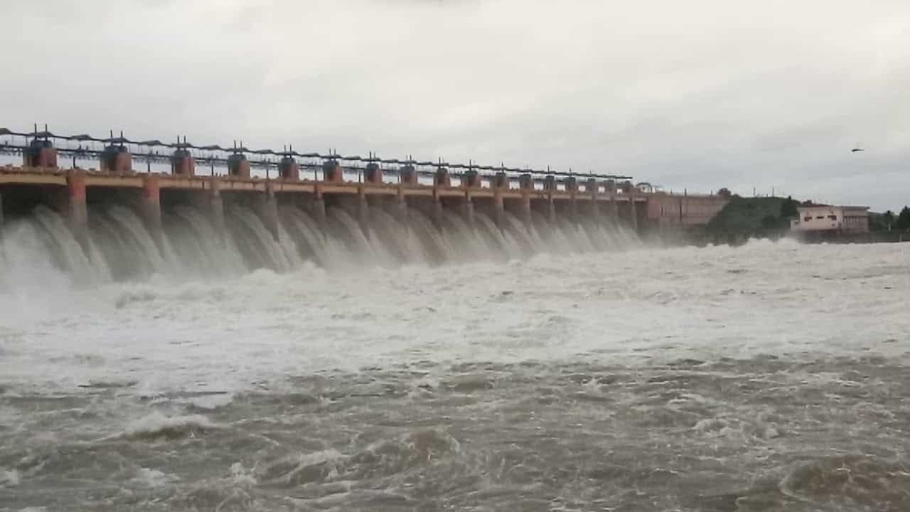
| Spillway Gates | 23 radial gates |
| Storage Capacity | 1,132 million cubic metres |
| Power Generation | 30.6 MW (3 x 10.2 MW Kaplan turbines) |
| Irrigation Potential | Around 247,000 hectares across both states |
| Best Time to Visit | September to May |
Where Matatila Dam Is Located
Matatila Dam sits in Lalitpur district, Uttar Pradesh, close to the Madhya Pradesh border, roughly 50 kilometres from Jhansi and just 8 to 10 kilometres from Talbehat. It connects the Jhansi to Babina route, making it genuinely accessible for travellers already exploring this stretch of the Bundelkhand region.
National Highway 44 provides a direct, well-maintained route from Jhansi, and the nearest railway stations at Matatila, Talbehat, and Lalitpur all offer reasonable connectivity, with Talbehat serving as a particularly busy stop. Visitors travelling from Delhi or Mumbai typically find Jhansi the most convenient railway gateway before continuing on toward the dam.
The River Behind This Bundelkhand Lifeline
The dam is built across the Betwa River, which originates near Bhopal in the Vindhyan plateau and flows entirely on rainfall, meaning it experiences high water discharge during monsoon and considerably lower flow through the dry summer months. After passing the outskirts of Jhansi and forming part of the border between Uttar Pradesh and Madhya Pradesh, the river continues mostly through Uttar Pradesh before eventually meeting the Yamuna in Hamirpur district.
This rain-fed, highly seasonal nature of the Betwa is exactly why a dam was needed here in the first place — without regulated storage, this drought-prone Bundelkhand region would swing between monsoon flooding and severe dry-season scarcity, with very little middle ground for reliable agriculture.
A History Rooted in a Goddess’s Hilltop Shrine
Before this dam existed, local belief held that a seat of Mata Sharda, a form of the goddess associated with wisdom and learning, sat atop a hill at this exact location. People worshipped this hill for generations, and it eventually came to be known as “Matatila,” combining “Mata” for the goddess and “tila” meaning hilltop. When the dam was constructed here, it inherited this same name, carrying forward a genuinely old spiritual association into a modern piece of infrastructure.
Construction ran through 1957 and 1958 as a joint project between the Uttar Pradesh and Madhya Pradesh governments, addressing water needs on both sides of the state border. The dam features a central masonry spillway flanked by earthen embankments, engineered specifically to handle the Betwa’s semi-arid, rain-fed conditions and the risk of sudden monsoon flooding that could otherwise destabilise loose, erodible soils during construction. Workers implemented specific compaction and reinforcement techniques in the earthen core to ensure long-term structural integrity, a genuinely important engineering consideration given the region’s challenging terrain.
The associated power house was constructed concurrently but only commissioned in 1965, adding hydroelectric capacity to what had initially been focused purely on irrigation and water storage.
An Honest Note on Structural Maintenance
It’s worth acknowledging this rather than glossing over it. Some sources mention that weaknesses in the dam’s walls have been noticed in recent years, though effective repairs have reportedly restored the structure’s stability. This is a genuine, ongoing maintenance consideration for a dam approaching seven decades of continuous operation, and it reflects the kind of upkeep challenges common to many of India’s older earthen dams.
What Matatila Dam Does for Bundelkhand Today
The scale of impact here is genuinely significant. Matatila supports an irrigation potential of approximately 247,000 hectares across both states, with around 179,880 hectares in Uttar Pradesh alone, of which roughly 68 percent has been utilised as of 2023. An additional 67,000 hectares in Madhya Pradesh receive water through the Bhander Canal system, extending the dam’s benefit well beyond just its home state.
This irrigation network relies on an extensive canal system drawing directly from the reservoir’s outlets, providing controlled water distribution to downstream farmland across a region that’s historically struggled with erratic rainfall and prolonged dry spells. Beyond agriculture, the dam’s power station, with three 10.2 MW Kaplan turbine units, contributes meaningfully to the local electricity grid.
What There Is to See and Do
The dam’s scenic setting is genuinely one of its biggest draws, with rolling hills, lush greenery, and the calm expanse of the reservoir creating a tranquil escape from city life. This vast water body is particularly picturesque during monsoon and winter, making it a favourite spot for nature lovers, photographers, and picnickers from across the wider Bundelkhand region.
The genuine highlight for many visitors is witnessing the dam’s 23 gates open during monsoon season, a spectacular sight that draws considerable local interest. It’s worth checking current conditions and news before your visit if this is specifically what you’re hoping to see, since gate operations depend entirely on water levels and aren’t something you can plan around with certainty.
Water sports facilities are available at the reservoir, and the surrounding area holds genuine eco-tourism potential under Uttar Pradesh’s broader 2022 tourism policy, with plans for camping sites integrating more sustainable, nature-based activities in the years ahead. Nearby, the Maa Malini temple offers a worthwhile spiritual stop, though it’s worth noting the temple typically closes between 12 PM and 3 PM, so planning your visit timing accordingly avoids disappointment.
Practical Realities Worth Knowing
There’s generally no entry fee to visit the dam itself, making it a genuinely accessible destination regardless of budget. That said, several visitor accounts mention that infrastructure and amenities around the site could use improvement, so it’s sensible to carry your own food and water rather than expecting extensive dining options nearby.
Given the region’s genuinely extreme climate, with summer temperatures sometimes reaching 50°C and winters turning noticeably cold, packing appropriately for whichever season you’re visiting in makes a real difference to your comfort.
Timings and Best Time to Visit
September through May is widely recommended as the ideal window, offering more pleasant weather conditions suited to outdoor exploration compared to the intense summer heat. It’s advisable to avoid the monsoon months of June through August for general sightseeing, given heavy rainfall, elevated water levels, and potential disruptions to road access, even though this same period is exactly when the dramatic gate-opening spectacle tends to occur.
Frequently Asked Questions
Q1. Why is this dam called Matatila?
The name comes from a hilltop shrine of Mata Sharda that reportedly existed at this location before the dam’s construction, with “Mata” referring to the goddess and “tila” meaning hilltop. When the dam was built here, it retained this same name.
Q2. Is Matatila Dam a joint project between two states?
Yes, it’s a genuine interstate project between Uttar Pradesh and Madhya Pradesh, with irrigation benefits extending across both states through separate canal systems, including the Bhander Canal supplying Madhya Pradesh.
Q3. When is the best time to see the dam’s gates open?
Monsoon season, roughly June through August, offers the best chance of witnessing this spectacular sight, though it’s worth checking current local conditions and news before planning a visit specifically around this, since gate operations depend entirely on water levels.
Q4. Is there an entry fee to visit Matatila Dam?
Generally no, making it an accessible destination for most visitors. It’s worth carrying your own food and water, though, since amenities and infrastructure around the site remain fairly basic according to recent visitor feedback.